
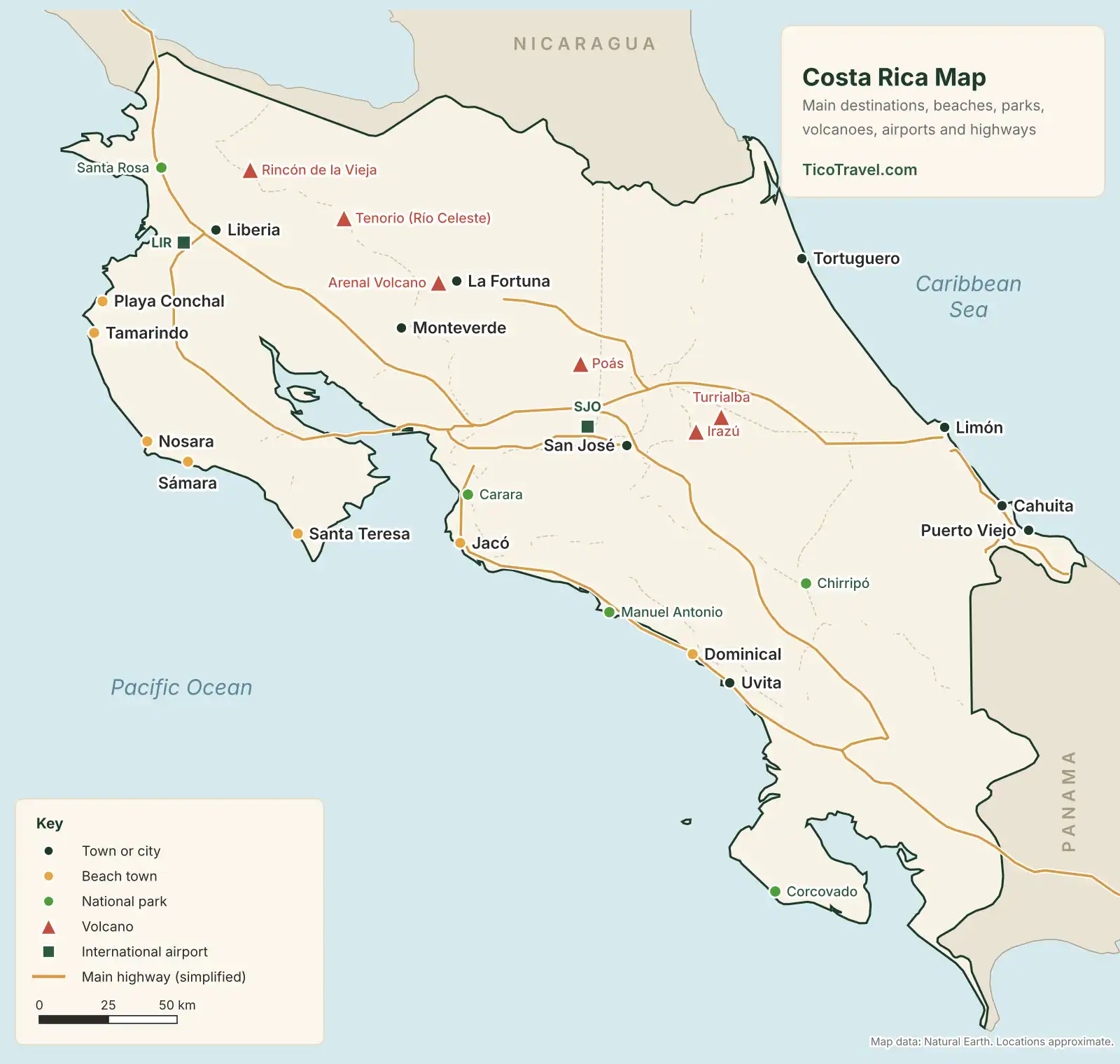
This Costa Rica map shows where the main towns, beaches, national parks, volcanoes and airports are, and roughly how long it takes to drive between them. The country is small, about 19,700 square miles, but mountain roads turn short distances into long drives. Where you base yourself matters more than most first-time visitors expect. Start with the interactive map, use the regional maps below to plan, and take the free printable PDF with you.
- 19,700 sq miTotal area, slightly smaller than West Virginia
- 2 airportsInternational gateways: SJO (San José) and LIR (Liberia)
- 4 hoursA sensible daily driving limit, finishing before dark
Explore
Interactive Costa Rica Travel Map
Open the map, then use the filters to show only what you’re planning around: destinations, beaches, parks, volcanoes, waterfalls and hot springs, or airports and border crossings. Click any pin for a short description and a link to our full article on that place.
Regions
Costa Rica Regions Map
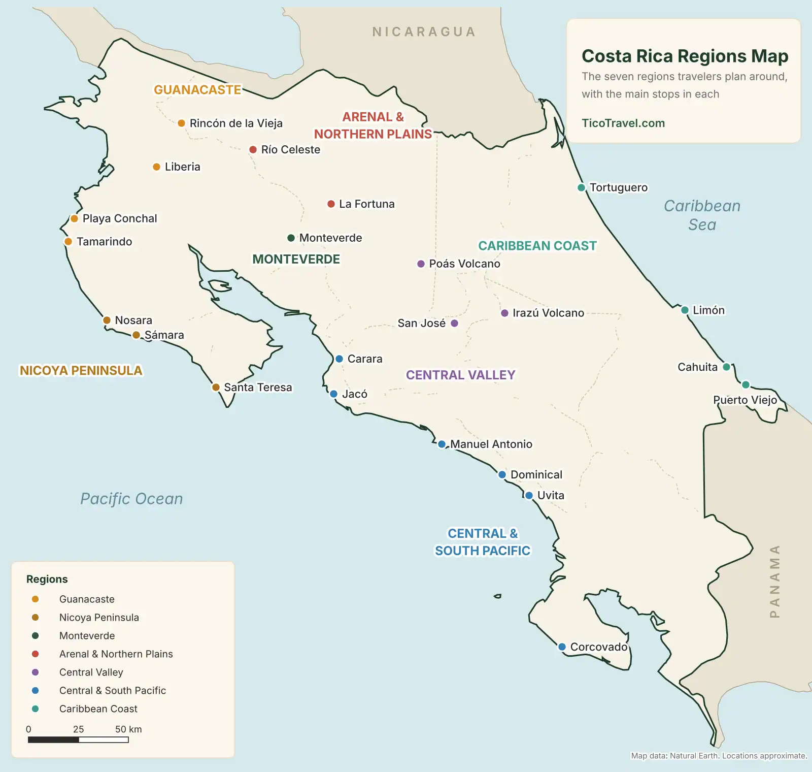
Travelers don’t plan by province. They plan by region: a cluster of towns that share a climate, a road network and a reason to go. These are the seven regions most trips are built from. Two or three of them fit comfortably into a week.
-
Guanacaste
The dry northwest and the country’s most popular beach region: Tamarindo, Playa Conchal, Flamingo and Playa Hermosa. Inland are Rincón de la Vieja and dry-forest parks. Fly into LIR.
-
Nicoya Peninsula
Surf and slower towns: Nosara, Sámara and Santa Teresa. Roads get rough near the coast, and the southern tip is reached by ferry from Puntarenas. Home to the Nicoya Blue Zone.
-
Monteverde
Cloud forest in the mountains between Arenal and the Pacific. Cooler, often misty, and known for hanging bridges, reserves and night walks. See our Monteverde article.
-
Arenal and Northern Plains
La Fortuna sits at the base of Arenal Volcano, with hot springs, La Fortuna Waterfall and Venado Caves nearby. Río Celeste is about 1.5 hours away.
-
Central Valley
San José, the SJO airport and the coffee-growing highlands. Day trips reach Poás and Irazú volcanoes, Catarata del Toro and Tapantí.
-
Central and South Pacific
Jacó, Manuel Antonio, Dominical and Uvita along the coastal Route 34, then the Osa Peninsula and Corcovado in the far south.
-
Caribbean Coast
Tortuguero‘s canals in the north, Limón in the middle and Cahuita and Puerto Viejo in the south. It has its own rain pattern, so check the best time to visit by region.
Beaches
Map of Costa Rica Beaches
Most of Costa Rica’s best-known beaches are on the Pacific side, from Guanacaste down to Uvita. The Caribbean coast is shorter and quieter, with a different food, music and rain pattern. Pick a beach by what you want from it, not by how close it looks on the map.
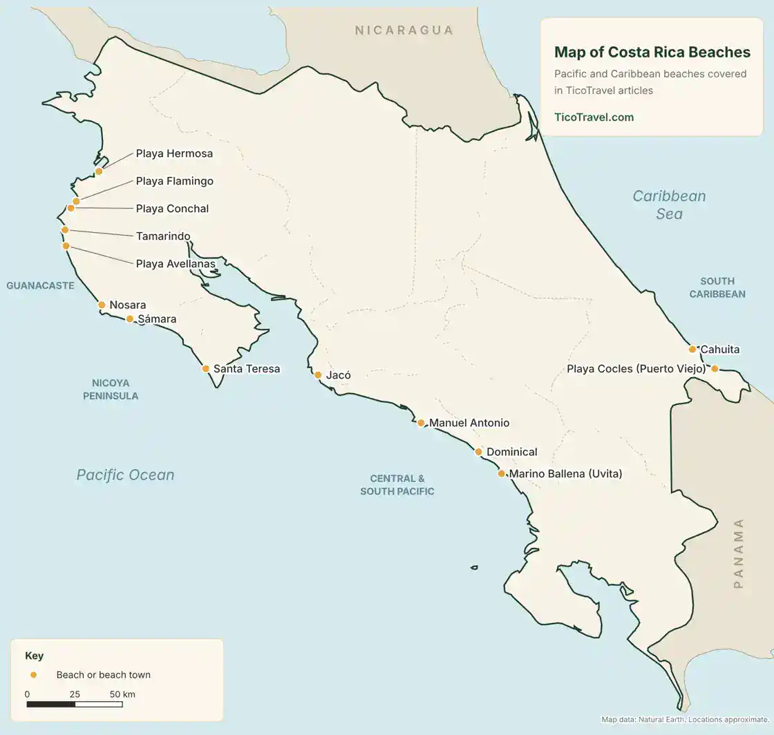
- Calm, clear water: Playa Conchal or Playa Hermosa in Guanacaste.
- First surf lesson: Tamarindo, with Avellanas nearby for a quieter surf day.
- Surf and yoga towns: Nosara and Santa Teresa on the Nicoya Peninsula.
- Wildlife on the sand: Manuel Antonio, where the beaches sit inside the national park.
- Experienced surfers: Dominical’s main beach, which has powerful waves.
- Caribbean culture: Playa Cocles and the beaches south of Puerto Viejo.
Our top 8 beaches in Costa Rica compares these in more detail.
Parks
Costa Rica National Parks Map
Costa Rica’s national parks and reserves are spread across every region. The most visited, Manuel Antonio, Arenal and Poás, are easy day trips from nearby towns. Corcovado on the Osa Peninsula is the hardest to reach, and every visitor must enter with a certified guide.
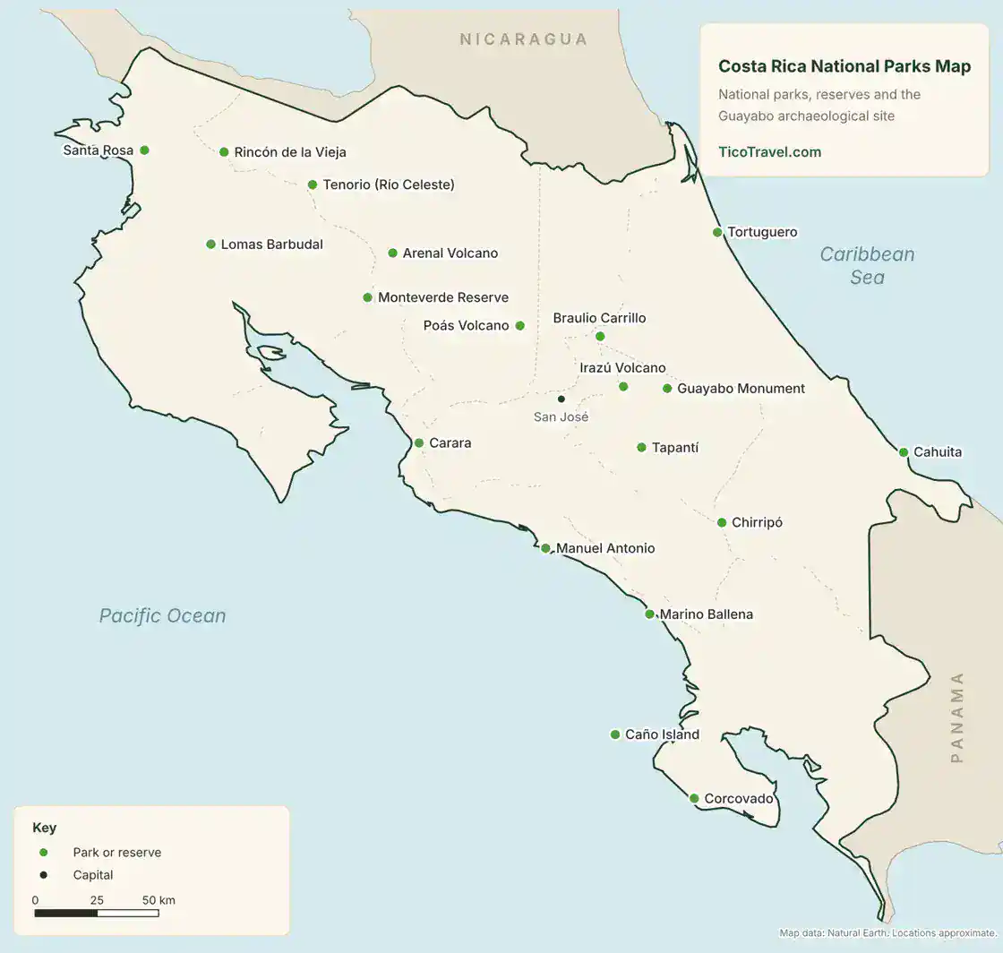
Manuel Antonio, Poás, Tortuguero, Tenorio (Río Celeste) and Carara sell entry online only, in timed slots, with no tickets at the gate, and Manuel Antonio is closed on Tuesdays. Book through SINAC, the national park service, before you go; our SINAC ticket guide walks through it. For individual parks, see Manuel Antonio, Arenal Volcano, Poás Volcano, Corcovado, Marino Ballena, Carara, Braulio Carrillo, Santa Rosa and Guayabo National Monument.
Volcanoes
Costa Rica Volcano Map
Costa Rica’s visitable volcanoes run in a chain from Rincón de la Vieja near the Nicaraguan border to Irazú and Turrialba east of San José. Arenal is the best all-round volcano trip, with trails, lava fields and hot springs, though you can’t hike to its summit. Poás and Irazú are the easiest crater visits from San José.
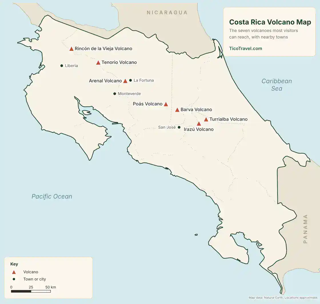
Several of these volcanoes are active, and access can change with little notice. Check the current status with our guide to volcano alert levels, and see the 7 best volcanoes in Costa Rica to choose between them.
Waterfalls
Waterfalls and Hot Springs Map
The volcanic north has the densest cluster of waterfalls and hot springs, with La Fortuna as the natural base. The south Pacific has a second group near Dominical and Uvita.
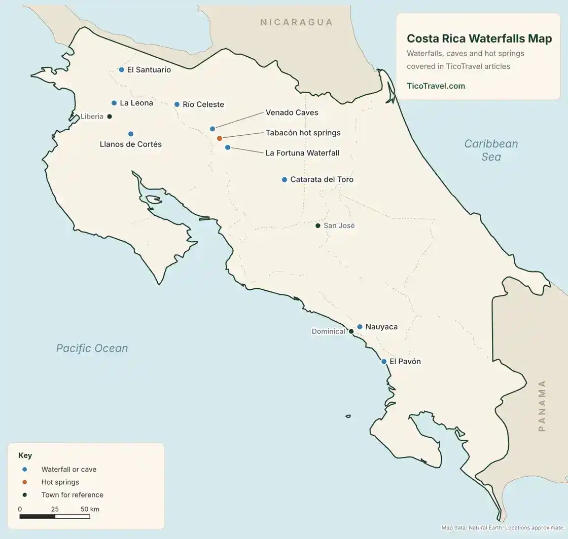
- Arenal area: La Fortuna Waterfall, Venado Caves and the hot springs, from free river spots to resorts.
- Guanacaste: Llanos de Cortés near Bagaces, La Leona near Liberia and El Santuario near Upala.
- Between Arenal and Guanacaste: Río Celeste in Tenorio Volcano National Park.
- Central Valley: Catarata del Toro in Bajos del Toro, an easy day trip from San José.
- South Pacific: Nauyaca near Dominical and El Pavón near Ojochal.
Getting around
Costa Rica Airports, Borders and Drive Times
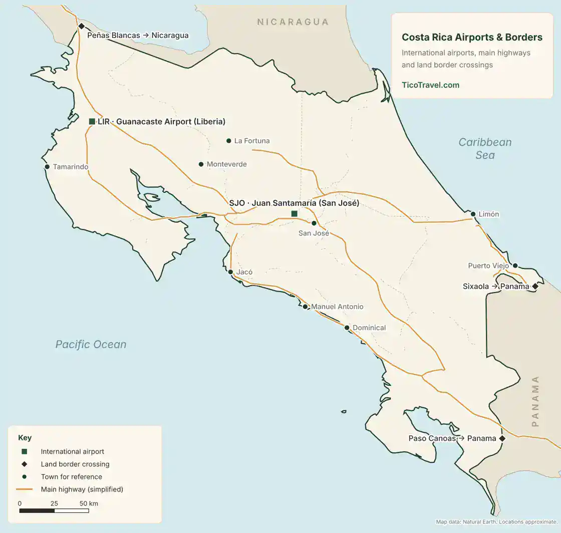
Costa Rica has two international airports. Juan Santamaría (SJO) near San José serves most of the country. Guanacaste Airport (LIR) near Liberia is the faster choice for the northwest beaches. Our airport guide covers the choice in detail.
| Destination | From SJO | From LIR |
|---|---|---|
| San José (downtown) | 30–60 minutes | About 4 hours |
| Jacó | About 1.5 hours | About 3.5 hours |
| La Fortuna / Arenal | About 3 hours | About 3 hours |
| Monteverde | About 3–3.5 hours | About 3 hours |
| Manuel Antonio | About 3 hours | About 4.5–5 hours |
| Dominical | About 3.5 hours | About 5–6 hours |
| Tamarindo | About 4.5 hours | About 1 hour 15 minutes |
| Puerto Viejo | About 4.5 hours | About 7–8 hours |
| Santa Teresa | About 5–6 hours, with the ferry | About 4.5–5.5 hours |
| Tortuguero | About 4–5 hours by car and boat | Usually routed through San José |
Times assume light traffic and no long stops. Traffic around San José, roadwork and rain can add an hour or more. Plan on four hours of driving a day at most, and be off the road by about 6 p.m., when it gets dark all year. For more, see our articles on driving in Costa Rica, rental car insurance, private transfers, public buses and Costa Rica road trips.
Land border crossings
- Peñas Blancas: the main crossing to Nicaragua, north of Liberia on the Pan-American Highway.
- Paso Canoas: the main crossing to Panama, in the far south on the Pan-American Highway.
- Sixaola: the Caribbean crossing to Panama, about an hour by road from Puerto Viejo, with onward travel to Bocas del Toro.
Planning a border run to reset your tourist stay? Read our visa run guide first for the current rules and exit fees.
Download
Printable Costa Rica Map (PDF)
The printable version fits on one letter-size page. It has the overview map with towns, beaches, parks, volcanoes, airports and main highways, plus an index of places by region. Print it before you go or save it to your phone for areas with weak signal.
Download the printable map (PDF)
FAQ
Costa Rica Map FAQ
How big is Costa Rica?
About 19,700 square miles (roughly 51,100 square kilometers), slightly smaller than West Virginia. For where it sits in Central America, see where Costa Rica is located.
How long does it take to drive across Costa Rica?
Longer than the map suggests. Liberia’s airport to Dominical takes about 5 to 6 hours, and San José to Puerto Viejo on the Caribbean takes about 4.5 hours. Mountain roads, trucks and weather slow most routes, so a 120-kilometer drive can take three hours.
Which coast is better for beaches, Pacific or Caribbean?
The Pacific has more beaches, more towns and the driest weather from December to April. The Caribbean is quieter, with Afro-Caribbean food and culture and a different rain pattern. Most first trips focus on the Pacific.
Do I need a 4×4 to get around Costa Rica?
Not for the main highways, which are paved, and the main road into Monteverde is paved too. A high-clearance SUV helps on the Nicoya Peninsula, on hillside roads to rentals and on most back roads from May to November, when rain turns gravel into mud.
Is Waze or Google Maps better in Costa Rica?
Waze is the most widely used, but download offline maps as a backup. Don’t follow either app onto shortcuts with steep unpaved climbs or river crossings, especially in the rainy season.
Can I print this Costa Rica map?
Yes. Download the free one-page PDF above. It prints on letter or A4 paper and includes an index of places by region.
The short version
Costa Rica is small on a map but slow on the road, so plan your trip around two or three neighboring regions.Fly into LIR for Guanacaste beaches and SJO for nearly everything else, and keep daily drives under four hours.Use the interactive map to explore, then follow the pins to our articles on each place.